 Beast Clock
That ever-optimistic Vancouver weather report said today would be partly cloudy, partly sunny, with a 30% P.O.P. (probability of precipitation), which is about as low as it ever gets. So we decided it would be a good day for a drive in the country.
 Beast Clock
We followed the driving directions in Joan Donaldson-Yarney's book, Back Roads - Southwestern British Columbia, starting in Pitt Meadows, about 20 miles east of downtown. We followed the Dewdney Trunk Road, named after the man who built a 4-foot wide trail in the early 1900s. We followed it all the way to Westminster Abbey, with numerous side trips.
Our first excursion was through blueberry farms to Pitt Polder, built in 1948 with the help of Queen Juliana, who lived in exile in Canada during WW II. The area is now a wildlife refuge that abuts Pitt Lake, which is the largest tidal freshwater lake in the world. (We're back to superlatives again.)
When we stopped to walk up on the levee next to the Pitt River we had to wait until a brief hailstorm subsided. The lady in the next car was talking about the storm on her cel phone as she returned to her car and extracted a large black umbrella and resumed her walk. Her dog, probably the real reason for the walk, didn't seem to mind, and happily retrieved an old shoe from the side of the levee. We did see some more logs tied up along the shore of the river.
We looked at the church of St. John the Divine in Haney. This is the oldest church in British Columbia, built in 1859. Since Derby, the town in  Raspberry canes
which it was built, became a ghost town, the church was moved to Maple Ridge in 1882. So, technically, the church of St. John the Divine in Yale (which we passed on our sea-to-sky circle tour a week ago) is the oldest church in British Columbia still on its original foundations.
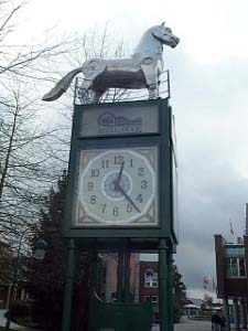
Then we saw the "Beast Clock." We think it should be called the Horse Clock, but the Back Roads author says the stainless steel animal on top is a "horse-like creature." Anyhow, it stands on its hind feet when the clock strikes the hour.
We continued to make frequent detours off the Dewdney Trunk Road, coming next to Golden Ears Provincial Park, where we drove through some miles of forest towards the mountains. The twin summits of Mount Blanshard turn golden with the autumn color, signifying the start of the salmon run.
There were lots of attractive hikes described in the book, but since the trails were steep and slippery and the weather was cold and rainy (also a little patch of snow for just a minute) we elected not to walk in the woods. But we  Why one when two will do?
ought to say that Vancouverians were out jogging, wearing shorts, apparently oblivious to the weather!
Webster's Corner had an old general store, but the principal interest was that Postmaster Webster, back in 1883, called everyone's name in turn when the mail came in, and opened all the unclaimed letters -- they should have been there at mail call time, he said!
The Dewdney Trunk Road crossed a hydroelectric dam next -- Stave Dam, named for the barrel staves that were cut from pine growing in the region. A major reconstruction effort was underway at the dam. On the other side we immediately ascended a series of steep switchbacks as we negotiated the side of a mountain, and then came to a very small neighborhood where the ground was covered in white - not snow, but more of the small hail. In this area the temperature had dipped to 37.
Westminster Abbey is no joke -- its full name is Westminster Abbey Seminary of Christ the King, a Benedictine abbey. Construction was begun in 1953, with a granite block from Monte Cassino as a cornerstone. It's a gorgeous modern building on top of Mount Maryann overlooking the city of Mission.
We had hot soup, hot tea, and sandwiches at Tim Horton's in Mission -- the first time we'd eaten at Tim Horton's since leaving eastern Canada last summer. Still good. Mission is actually named after St. Mary's Indian Mission, founded here in 1861.
 Peace Arch
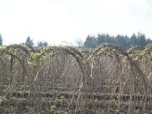
We headed south across the Fraser River, stopping in the tiny old town of Clayburn, and then wound our way through Abbotsford to 0 Avenue, and drove due west along the U.S. border. There's a Berry Festival the second weekend in July; 34.5 million pounds of raspberries are shipped each year. It's the second largest raspberry production area in North America. We saw field after field of raspberry canes, tied together to support the fruit, and just beginning to leaf out.
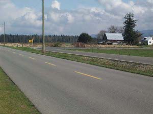
We also saw the boundary markers every mile along the road. The U.S. and Canadians each surveyed part of the border, and then checked each other's work. The farms look the same on both sides, there's sometimes a fence, sometimes a ditch, occasionally neither. In one section two roads lay parallel, a few feet apart, on either side of the border.
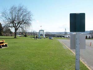
We curved around the border stations at B.C. Highway 13 and 15 and came to a third station where U.S. I-5 runs into B.C. Highway 99. There's a Peace Arch, and a Peace Park, and hundreds of rock fans were attending a Peace Concert (or something) and Picnic.
By this time the sun was shining brightly and the temperature was 50. Go figure Vancouver weather!