 Capilano Suspension Bridge
The Lions Gate Bridge is three lanes total, and throughout our visit a good sized crew has been performing major bridge repairs. We joke about how they need to keep welding things together so the bridge doesn't collapse while we're crossing! In the morning it's two lanes coming in to the city, so the outbound traffic moves at a snail's pace. Opinion is divided whether to build a new bridge or expand Lions Gate; the problem with the latter is that it ends in Stanley Park, and nobody would dare destroy any of the park's property or landscaping, so they struggle along.
 Capilano Suspension Bridge
After we crossed the Lions Gate we turned onto Capilano Road and shortly found ourselves at Vancouver's oldest tourist attraction. The first Capilano Suspension Bridge was built in 1888 with hemp rope. Tourists used to spend all day hiking up the trails to reach the bridge, owned by Scottish immigrant George Mackay.
The bridge has been replaced several times; the current version is suspended from heavily-anchored steel cables and successfully withstood a 1960s storm in which 8 trees, most of them huge Douglas firs, fell upon it.
Still, it's a suspension bridge, so it wobbled and resonated with our footsteps as we crossed. It's 450 feet long and 230 feet down to the white waters of the Capilano River below -- a thrilling view. On the far side we took a short trail through the forest, past some ponds the owners have stocked with trout -- the sign said most of the fish were eaten by an enterprising otter! There were excellent interpretive signs pointing out the firs, cedars, spruces, covered with green moss, along with the rich, dark, fern-covered forest floor. The cedars which fell during the big storm are now providing nutrients to spruces which sprouted where enough sunlight penetrated the canopy.
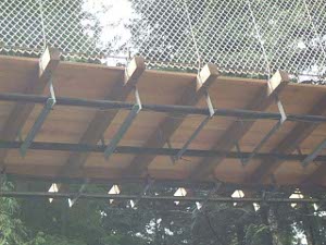
 Capilano bridge construction
We were lucky to have come early, as the bridge and forest were quiet and tranquil; later in the morning both parking lots were full. It would be quite crowded during the height of the tourist season.
The park has several other attractions, including a good story board history and a large collection of totem poles; the local Salish indians were taught to carve the poles as a source of income. Two first nation woodcarvers were demonstrating their craft in a small shop behind a glass window. The gift shop is very large and well-stocked.
Our next stop was the fish hatchery, where we passed a busload of Japanese businessmen just leaving. Whereas a trout hatchery is mostly of interest to sport fishermen, a salmon hatchery, such as this one, has commercial significance as well. The signs described the growth of the salmon from eggs to alevins to smolt to salmonids to full-sized salmon, but failed to indicate at what times of year various hatchery activities occurred.
We stopped next at Cleveland Dam to see the impressive spillway. This reservoir is part of the Vancouver drinking water system; the claim is that its builder was the first (again in the 1890s) to restrict access to the water in order to preserve its purity. Humans may not approach, but log booms and a spill of logs at a clear-cut hillside indicate what government agencies call a Multi-Use Environment.
Further north on Capilano Road is the largest aerial tramway in North America; but it was covered in cloud -- in fact beginning to rain lightly -- so  Cleveland Dam spillway
we decided to wait for another day. We also passed on the Maplewood Children's Farm; we were too early to watch the cow being milked. (Have you noticed that the animals on children's farms these days are never slaughtered? It's just dairy and eggs and farm pets.)
We saw a sign for Environment Canada, so we drove in. It turned out to be Maplewood Flats Wildlife Sanctuary. We were flush from having successfully identified (a) a common merganser and (b) a varied thrush in the woods by the fish hatchery, so we decided to have a look. We did see another bald eagle, its white head and dark body unmistakable, sitting on top of one of the pilings in the river. There were supposed to be a pair of nesting ospreys, but we couldn't spot them. The woods were full of song, and we wished we knew all the bird calls. But it was soon raining quite steadily, so we went back to the car to find a warm dry place for lunch.
We found it at a tiny but excellent Japanese restaurant in Deep Cove, a lovely little village with a small picturesque harbor on the Fraser River.
We drove on towards Lynn Canyon, thinking we might walk around the ecology center there. But it was still raining - in fact we passed through another neighborhood where the grass was covered with tiny white hailstones - so we decided to go home. On the way we drove through the waterfront districts of North Vancouver and Vancouver, past giant coal docks and grain docks and container docks along the river.