We got on the road pretty early and drove to Victoria. It's about 70 miles, 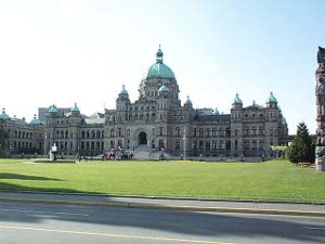 British Columbia Parliament
and it took us about an hour and a half. The Trans Canada Highway here is a four-lane divided road with a lot of cross streets and a lot of traffic. We cruised into Victoria, past a sign that said, "Tourism is Victoria's biggest industry; it brings in more than $1 billion a year." and found the harbor, and a place to park on the street for an hour. Then we walked to the Tourist Office.
On the way to the Tourist Office, we kept passing things of interest. First there was a plaza full of plaques and monuments celebrating the creation of the Province of British Columbia. Then there was the provincial parliament, right across the street. The horse-drawn hansom cabs were lining up and taking their first tourists for a ride. Across that corner was the wax museum, but it looked like some former government building, with great stone pillars, kind of Greek revival. We walked down to the harborside, to a little plaza with a monument celebrating the great treaty between Great Britain and Russia which  One of many floral displays
fixed their common border. It took us a little while to realize that they were talking about the border between the U.S. (Alaska) and Canada (Yukon), because neither the U.S. nor Canada were mentioned on the plaque.
We turned and looked across the street at a big and recent totem pole. Then we looked down to the harbor and saw an underwater garden (another tourist attraction), and an old Canadian Forces frigate, and a good looking two-masted sailboat. Trooping down the street came a file of people in red suits. They looked like sanitation workers or perhaps sea scout trainees going to board the sailboat. But no, we were wrong. They got into high-powered rubber rafts. These were tourists, on their way out of the harbor on the PRINCE OF WHALES rubber boats. The red suits were evidently to keep off most of the water. We decided that any boat trip that required getting completely dressed in a red waterproof suit was not for us.
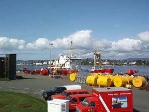 Coast Guard base
Next we heard a blast of a ship's horn and turned around to see a ferry entering the harbor. We walked back down the harbor to see what it was. It turns out that only ferries from the U.S. dock in Victoria Harbor. By this time we've already got the picture. They want the rich American tourists to have the fabulous entry into this picture-postcard perfect harbor, flanked by Parliament and the Empress Hotel, with plenty of resort hotels within a couple blocks of the ferry landing and plenty of tourist attraction ready to go. As we saw all this a seaplane revved its motors and taxied out of the harbor -- presumably bound on a sightseeing flight.
We returned to our walk, noting the big display of flowers. The tulips are out! A week ago in Minter Gardens only a few had opened up, but today, all 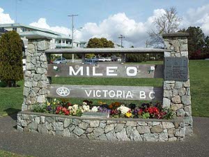 Western Terminus of the TCH
over Victoria, were thousands of tulips in all imaginable colors and hues. A riot of blooms! We photographed things from all possible angles, enjoyed the life-size statue of Captain Cook (but not Captain Vancouver) and proceeded to the Visitor Center, where we got some more brochures and maps.
In deference to the one with the gimpy ankle we decided to take the walking tour by car. The site of the former Fort Victoria, a few nineteenth-century buildings, the Eaton Center where one could find lots of fabulous shops, a modern fountain, a modern mural showing a pod of orcas, and the old lighthouse light, with a Fresnel lens familiar to any Coastie, rounded out the suggested tour.
Between its little shops and tea rooms and flower-gardened cottages, Victoria is a vision of an Imagined England, another draw for Americans as well as Canadian tourists.
Planning a later second trip for museums and shopping, we set out to 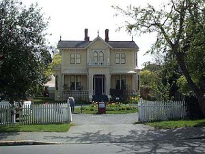 Emily Carr Birthplace
circumnavigate the Saanich Peninsula. Leaving downtown, we passed a large condominium project still half-completed, the fishing fleet in their own harbor (none of the boats was out working), the Canadian Coast Guard Base, with a buoy tender at the pier along with lots of small boats, and the cruise boat pier. It's a little early still for cruise boats, but we're sure they'll be starting in May. In the outer harbor a powerful pilot boat kicked up a tremendous rooster tail ferrying the pilots to and from the ships at anchor, and we saw the ferry heading back to Port Angeles, Washington.
Then, around the corner, we came to a place we had wanted to see: Milepost 0 of the Trans-Canada Highway, which runs 4860 miles to St. John's, Newfoundland (where we had already seen the other Milepost 0). It's kind of interesting to realize that, whereas the U.S. is commonly thought of as about 3000 miles from ocean to ocean (a little less from Florida to San Diego, a little more from Maine to Washington), Canada is more than half again as wide. It's a really big country. We saw the monument for a cross-Canada runner (72 days, 10 hours), who made the run to raise money for charity, and just as we were climbing back in the car, three tour buses discharged Japanese tourists, all of whom photographed one another standing in front of all the monuments.
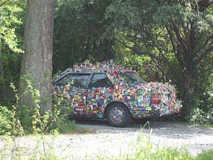 Personal Vision, Automotive
We meandered around the Children's Farm in Beacon Hill Park, which was crowded with children and farm animals, and waited patiently while two peacocks crossed the road. Then we followed the Marine Drive hugging the south coast, past plenty of waterfront mansions, old and new, and several marinas filled with yachts.
Every time our route took us through an Indian Reservation (about six times today) we noted the run-down houses and evidences of poverty. On one reservation numerous homes were boarded up, marked health hazard -- we think because of asbestos.
Sidney is the principal port of Entry for ferries from Vancouver and Anacortes, as well as for yachts cruising the Inside Passage. We saw plenty of beautiful yachts, both sail and motor, in the boatyards and marinas. The northern tip of the Saanich Peninsula is hilly, and there was another rush of beautiful hillside waterfront mansions in this area.
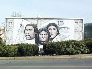 First Nations mural, Chemainus
Coming down the West side of the peninsula we drove through the Victoria International Airport (it's about 20 miles north of the city) and then found the TCH to head back north. We left the divided highway again in Duncan, to detour to Maple Bay - a beautiful protected harbor - and Crofton - with all its fishing boats in harbor, too - and then to Chemainus.
Chemainus is an incredible little town of 30,000 that decided to spruce up its downtown blocks by having murals professionally painted on the building walls. There are more than 30 so far, some of them quite striking. Quite a few retell a bit of Chemainus history. The town won the 1994 British Airways Tourism Award, among more than 200 competing communities.
We were on the road about 10 hours, but we think it was a wonderful trip. The downtown harbor of Victoria is a must see, and we plan to return to see a sight or two. But there's a lot of very beautiful and remote wilderness on this island, and we hope to do some wider exploration.
 British Columbia Parliament
and it took us about an hour and a half. The Trans Canada Highway here is a four-lane divided road with a lot of cross streets and a lot of traffic. We cruised into Victoria, past a sign that said, "Tourism is Victoria's biggest industry; it brings in more than $1 billion a year." and found the harbor, and a place to park on the street for an hour. Then we walked to the Tourist Office.
 One of many floral displays
 Coast Guard base
 Western Terminus of the TCH
 Emily Carr Birthplace
 Personal Vision, Automotive
 First Nations mural, Chemainus