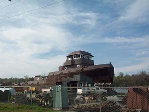
 Boat building, Morgan City
away from the city, with cypress swamps, occasional boatyards, small towns where the small houses front on a canal; residents draw their boats up on the grass in front of their house.
Boat building, Morgan City
away from the city, with cypress swamps, occasional boatyards, small towns where the small houses front on a canal; residents draw their boats up on the grass in front of their house.
Morgan City, Louisiana, bustles with activity along its waterfront. The Historic District has retained some picturesque shopfronts. Floodwalls remind us that it's spring, and this year's snow melt hasn't reached Louisiana yet.
From Morgan City we followed the waterfront much of the morning, snaking around the southern side of New Orleans. We could have been hundreds of miles
Boat building, Morgan City
away from the city, with cypress swamps, occasional boatyards, small towns where the small houses front on a canal; residents draw their boats up on the grass in front of their house.
In Algiers, on the southeastern end of the city, we took a ferry across The Big Muddy; the captain did an impressive job of dodging the mid-river barge traffic and the returning ferry.
Waterfront industries are generally heavy industries, and that's a lot of what we saw on today's drive. We passed drydocks and shipyards and oil refineries and sugar refineries and saw more barges and ships and working boats than we could count. There were dozens of heavy cranes for loading ships and barges; one huge crane looked like its capacity was a hundred tons or more.
We made up for yesterday's Subway sandwich with fried oyster po-boys today, enjoying our last chance for Louisiana cooking for this trip.
Along the road we continue to enjoy small-town signs, such as: "Amps - Woofers - Alarms - Guns - Pagers"; or "Roadside Daiquiris."
In Gulfport, Mississippi, we found the beginning of the chain of casinos which fill the Gulf coast across the state. In November, on our trip west, the beaches had been closed for protection for nesting plovers. Today the big machines were out, grooming the sand in preparation for the spring tourist 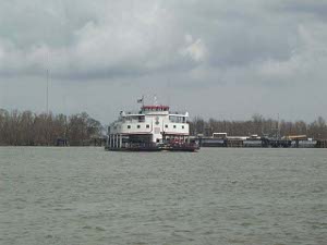 Mississippi ferry, Algiers
season. A few families walked the beach, or introduced toddlers to the water.
Mississippi ferry, Algiers
season. A few families walked the beach, or introduced toddlers to the water.
Across the highway from our motel, a giant container ship is being loaded with steel cargo vans: SS Dole Honduras is getting ready to leave port.
Here's a question: Just east of Bay St. Louis, the road crews were out diligently working on a stretch of Highway 90 several miles long. They had completed work on the slow lane and were working on the fast lane. Here's what they were doing: they were using a concrete saw to cut grooves in the pavement. The grooves were organized in groups of six, spaced quite closely together -- say about ten feet apart -- going down the highway for miles.
Three of the grooves were on the left, about where the left tire of a car or truck would ride; the other three were on the right, about where the right tire would ride. Each groove seemed to be a couple of inches wide and a couple of feet long. The grooves were parallel to the direction of the highway. Can any of our readers explain this process?