 Nebraska State Capitol
and a visit to the State capitol, but heard not one word about football. Our readers may draw their own regional cultural conclusions.
Nebraska State Capitol
and a visit to the State capitol, but heard not one word about football. Our readers may draw their own regional cultural conclusions.
In Ocala a couple of weeks ago our motel was filled with rowdy Tennessee Volunteers football fans -- and Ocala was an hour south of the stadium in Gainesville. They wore orange shirts at breakfast, joked loudly with each other, and sped northward in vans with pennants to the Gator game. But last night in Lincoln, Nebraska, no one even seemed aware that a Cornhusker's home game was taking place. We dropped off the laundry, inquired about restaurants
Nebraska State Capitol
and a visit to the State capitol, but heard not one word about football. Our readers may draw their own regional cultural conclusions.
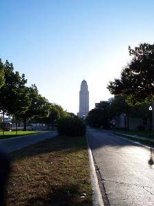
The State Capitol building dominates the solid but otherwise unremarkable city of Lincoln. It rises 400 feet into the air, an example of the rather mystical architectural styles of the 1920s and 1930s, with mosaic tiles decorating the upper stories, and a statue of The Sower topping the whole thing. In front of the building is a statue of Abraham LIncoln by Daniel Chester French who also sculpted the famous seated Lincoln in Washington.
Eastern Nebraska is filled with prosperous farms, and fields of corn, beans, and milo, but mostly corn (else what would they husk?) The harvest is going on, so many of the fields were half cut, the farmers generally not working on the weekend (perhaps they were watching their sons play football on Saturday, or going to church on Sunday.) The highways and railroads follow the old wagon trails, which in turn followed the rivers flowing gently eastward across the great plains, most of them draining into the Platte, which flows into the Missouri which flows into the Mississippi which we just crossed last week. The river beds can be distinguished by lines of cottonwood trees. We headed towards the source of the waters, eventually following the Middle Loup River, thinking about the wolves for which it was named a few hundred years ago by French trappers.
Avoiding the freeway, we started out on U.S. 34 westbound, ignoring the signs every few miles urging us to turn south to take I-80 instead. But we almost came a cropper, as a sign mysteriously informed us that "U.S. 34 closed to Seward." We soldiered on, guessing correctly that a bridge was out. There was plenty of local traffic. Four miles east of Seward one tiny sign indicated a detour to the north. We never did find out where the detour went. 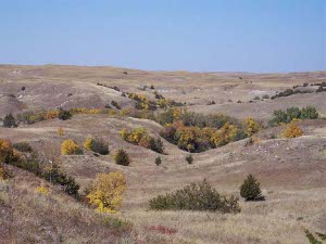 Autumn in the Sandhills
Instead we drove up to the closed bridge, and wandered along a gravel road moving in the direction of the river (creek, actually) to be crossed. We spied a woman raking autumn leaves, and made inquiry. In a high-pitched Scandinavian voice she told us to keep going and there was a bridge (this was just a block north of the washed out bridge) and we talked about where we were from and how we traveled all over, and so on.
Autumn in the Sandhills
Instead we drove up to the closed bridge, and wandered along a gravel road moving in the direction of the river (creek, actually) to be crossed. We spied a woman raking autumn leaves, and made inquiry. In a high-pitched Scandinavian voice she told us to keep going and there was a bridge (this was just a block north of the washed out bridge) and we talked about where we were from and how we traveled all over, and so on.
We knew we were back in the heartland the moment we spoke to this Nebraskan woman. Midwesterners are friendly and chatty. They wave from their porch to passing cars. They wave from the driver's seats of their pickup trucks. Soon we found ourselves listening to Garrison Keillor reading birthday greetings and telling stories of life in Lake Woebegone, Minnesota, so we were getting into the spirit of prairie neighborliness. At a gas station, a rancher opened the door of his horse trailer to show us his new filly, returning from the vet (she had cut herself on a bit of barbed wire but was recovering nicely). At another gas station we exchanged comments on windshield bugs and duck hunting with a friendly local couple, and also chatted with a Baptist preacher who had grown up about 14 miles away, had moved out of the area (across the state) but was back home now and happy to be here.
We took the Sandhills Scenic Byway, but didn't realize until we got to our motel that we were passing through the "largest stabilized sand dune formation in the Western Hemisphere" (19,000 square miles). What this meant to us was that all the corn, beans, and milo by the side of the road disappeared for a few hours while we drove through sandy grasslands, populated only by ranchers and their cattle (not counting the wild critters), and dotted with tiny towns of a couple hundred souls. The traffic pretty much disappeared, too. We did find gas stations, but the Nebraskans are installing 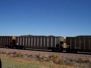 Coal cars
unmanned 24-hour stations along this road.
Coal cars
unmanned 24-hour stations along this road.
What was interesting was how many trains we saw. We must have passed a dozen going east, and half-a-dozen heading west. Each was about a hundred cars long, and none of them carried any passengers. The operations dispatcher must have had a busy day keeping all those trains sorted out, and letting the trains going in opposite directions switch onto the doubled track for passing, then back onto single track. They always passed in the English style, keeping to the left. About two-thirds of the trains were for Wyoming coal, with empty coal cars returning westward to load up while loaded cars headed east, we know not where. It's the first time in memory in which we passed far more trains than cars as we drove.
Near the western end of the Sandhills Scenic Byway, the land, which had been gradually rising, levels off into a region of marshy lakes. If we had driven this road in April we would have seen a zillion or so migrating sandhill cranes, but this October day there were just mallards in the lakes.
On the outskirts of Alliance there was a big car barn where coal cars were shunted off and repaired; possibly new cars were built here, too. Alliance, in railroad terms, is a "division point," meaning there are huge yards for composing engines and cars into trains and changing crews.
Since we found a motel in Alliance, we decided not to go north to Chadron tomorrow, so we will miss the museum of fur trapping, but we always like to leave some sights unseen for the next trip!