 Kelleher School sculpture
We decided to drive to furthest western Ontario before crossing the border at Rainy River. At nine o'clock on a misty Sunday morning nothing much was happening in that town. We stopped at Canadian customs to get official stamps on our motel receipts (the Canadian government reimburses the taxes on accommodations for tourists, a nice touch we recommend to our own country) then zipped over the bridge and changed our last small batch of Canadian money. Home again.
 Kelleher School sculpture
Almost immediately we saw some differences between Minnesota and Canada. We passed several small lumber mills; in Canada all we saw were the behomoths operated by Domtar, Abitibi and the like. It reminded us that small business enterprises, in tiny towns, are more common in general in the U.S. than elsewhere. As we moved south we found several large fields of sunflowers (all bowing their heads in the fog!).
We swapped driving/passenger roles at a schoolyard in Kelleher, Minnesota, where we happened to find a most beautiful outdoor sculpture with a den of wolves in the roots of a twisted pine and an eagle on top (see photo.) The sculptor is a native Minnesotan, Sam Spiczka, born in 1977 and the sculpture was his first major commission.
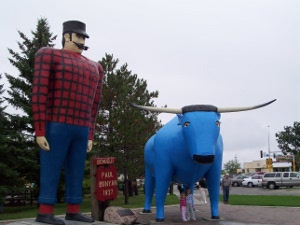
We headed for Bemedji, home of Paul Bunyan and Babe the Blue Ox. Actually, since Paul and Babe are American legends, their homes are fictional as well, but ever since 1937 their giant replicas have stood near the lake in this town. For years Babe was carried on floats in parades, but finally she was cemented in place next to Paul. After our weeks in logging country, with more tree farms and forests in Minnesota as well, we appreciated this giant pair, knowing that Paul and Babe could never understand the idea of a mill machine the size of a football field.
 Paul Bunyan and Babe
Now rivers are interesting topographical phenomena. Water runs across the land in a broad, deep channel, nourishing the soil and providing cheap transportation. But rivers tend to get all squirrelly near the beginning and the end, splitting up into smaller and smaller tributaries and creeks and brooks at the start, and fanning out over flat deltas where they dump into the ocean.
People have been fascinated with the naming of rivers. The Native Americans gave different names to different parts of the Mississippi, not treating the entire river as a single thing. But property-conscious Europeans used rivers as territorial boundaries, so the defining and naming of rivers became quite important. And then of course explorers loved to achieve immortality by having their name on some piece of geography. To complete the introduction of this topic, we might ask you to consider why the Ohio River doesn't have a source.
The Mississippi does have a source; it rises in the land of 10,000 lakes, north central Minnesota. This has led to an interesting historical dispute, for there are lots of lakes and rivers, and rivers flowing into and out of lakes. And there's no clear geographical answer, because you can always argue about things like when is a river not a river (but a creek, brook, rill, stream, . . .) or which tributary is the real river. Westerners might think that the Mississippi should head west out of St. Louis, for the so-called Missouri - Mississippi river system is quite a bit longer than the Mississippi itself. But the Native Americans never could understand what the fuss was about; who cared which was longer?
So we say that deciding on the headwaters of the Mississippi is more politics than geography! That said, the definition that has been chosen  Source of the Mississippi
is a particularly pleasant one. Lake Itasca is a wishbone-shaped lake in the heart of the high Minnesota watershed, and the stream that leaves Lake Itasca flows into Lake Bemidji as a river, then leaves Lake Bemidji and flows into Cass Lake, then into Winnibigoshish Lake, and when it leaves there is no doubt that this is the river that flows south to the Gulf of Mexico. It takes about 90 days (they say) for water from Lake Itasca to reach the Gulf, but we're not so certain the flow of water is that easy to describe.
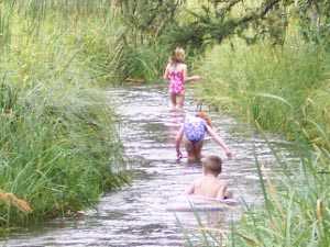
In any event, Lake Itasca State Park is beautifully developed, with wilderness drives and hiking and biking trails, lots of accommodation, beautiful visitor centers. In fact, we think it would be just as attractive a destination as quite a few of our national parks. The forest is old growth, the lakes are clear, and there, at the headwaters of the Mississippi, children are wading across and floating in inner tubes and getting their pictures taken (And to tell their children: When I was a girl I walked across the Mississippi river!)