 Tallest Ice Cream Stand in the World?
community, mostly retired folks, scratching a low-cost living in the driest of dry desert. Lately, writings about Pahrump have noted that the town has grown quickly, becoming citified.
This was a delightful day where we covered known ground and found interesting new sights to see, plus delicious food to eat!
We began with breakfast at the Blueberry Hill Family Restaurant near our hotel. It was a massive plate for each of us with bacon, eggs, crepes with blueberry compote (Bob) and pancakes with blueberry compote (Elsa). The entire breakfast was cooked just right and the waitress brought milk for our tea.
This led us into a bright sunny day and our drive into the southwest desert of Nevada. When we lived close enough to make occasional weekend trips, this part of the state was our most frequent destinations. We thought we knew all about Pahrump - a small desert  Tallest Ice Cream Stand in the World?
community, mostly retired folks, scratching a low-cost living in the driest of dry desert. Lately, writings about Pahrump have noted that the town has grown quickly, becoming citified.
We began our drive with a 10-mile, 35-minute drive across Tropicana Avenue (previously Bond Road, but renamed for the hotel), across the heart of the Strip. When we turned left on Rainbow Drive we noticed that Tropicana was still thickly settled far to the west. The thing is, Las Vegas has simply spread out in all directions.
Years ago, it seemed to us, Bue Diamond was a 2-lane country road that ran from I-15 past the settlement of Blue Diamond, over the pass and around to the west of Mt. Charleston (11,916 ft.) and the tiny town of Pahrump.
No more. Blue Diamond Road now resembles a freeway, well engineered with limited access and broad divided traffic lanes past the newly developed community of Mountain Pass. It is a route for Las Vegans of the mountain-loving variety to reach their destinations, as well as the causeway to the fastest booming city in Nevada, Pahrump, sixty miles away.
Mountain locations are very popular in Las Vegas, because of the blistering summer heat, but even on this winter Sunday there was plenty of recreational traffic up into the hills. Cars, campers, motorcycles, off-roaders were gathered at meeting places along the highway.
On the western slope the traffic eased a little as we descended to a familiar dry desert landscape. But when we crested the final rise before we could view the Pahrump  "Coffinwood"
valley we couldn't believe our eyes -- it seemed the entire valley was covered with buildings, as the bare desert had been replaced by homes, ranches, businesses, hotels, casinos, fireworks stands, and saloons.
Our earliest memories of Pahrump go back to the 1970s, when it was a tiny settlement of really inexpensive desert homes, including many mobile homes. There were a couple of casinos and saloons and motels, and you could continue on back roads into desert California (one road to Shoshone and Baker, and another to Death Valley Junction and then Death Valley.)
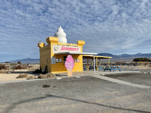
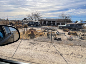
Pahrump is still a home for oddities. Our photo of Seemore's Ice Cream Stand shows a vast unpopulated area surrounding the building. Coffinwood is a private residence, also surrounded by nothing, and featuring coffins for porch pillars, a fleet of hearses, and a pet cemetery in front.
In 2018 the population of Pahrump was 36,174, making it the 12th largest city in the state, and the fastest growing. With an area of 364 square miles it is the largest CDP (census designated place) in the lower 48 states, and has a population density of about 100 people per square mile. That was consistent with what we experienced today as we drove about the vastly spread-out community.
It was time for lunch. We were happy to find Weiss Restaurant and Deli-Bakery in Henderson, where we had wonderful seeded rye bread, half-done pickles, pastrami, chopped liver, creamed herring and potato salad that made us remember our days in "The City" (New York)!